 So on the 4th Apr I just needed some wilderness and had to get away, so decided on a training run to Mayo and Mweelrea, the highest mountain in the province, and situated nicely on the Wild Atlantic Way. So on a new route I’d not done before, I must say I was a little apprehensive as I’d proposed to tackle this one solo, aware that a climber lost his life on a section of this route last year and it took a concerted effort from the rescue workers, a full week to find his body.
So why go solo? Well 1, any climbing buddies I’d trust were all busy this day and it was just kinda last minute had to go or I go mad.
2, People will tell you don’t ever do something like this on your own, what if something goes wrong? Couple of answers to this one,,
a: If I was to always wait for a buddy, and try to arrange times we’re all free at same time, it might never happen, yet I need the training. Can I afford to go mad at home and miss out?
B: Have I got confidence in my training, equipment and ability to make decisions at a moment’s notice in order to look after myself, change route and plans or call it off for another day if necessary?
C: Have I left route details and agreed check in times with a buddy, who’s gonna alert rescue services in case of not hearing from me by a certain time?
Depending on how you answer these questions truthfully and accurately will then tell you go or no go. Also, do you guide another up a mountain if you can’t guide yourself? Also, I’ve heard it said by a well-known and highly respected mountaineer and adventurer, when asked why these adventures solo. Isn’t it dangerous?
Well it reduces the likely hood of someone making a mistake and getting injured. If there’s two of us, there’s twice the chance someone will go wrong. Also you might get distracted or your buddy might not be happy with route. If I mess up it’ll put my pal in jeopardy or vice versa, so looking at it this way there’s a good argument to go either way. Great if you have peers at same level or higher, but you can’t advance if you gotta sit around waiting.
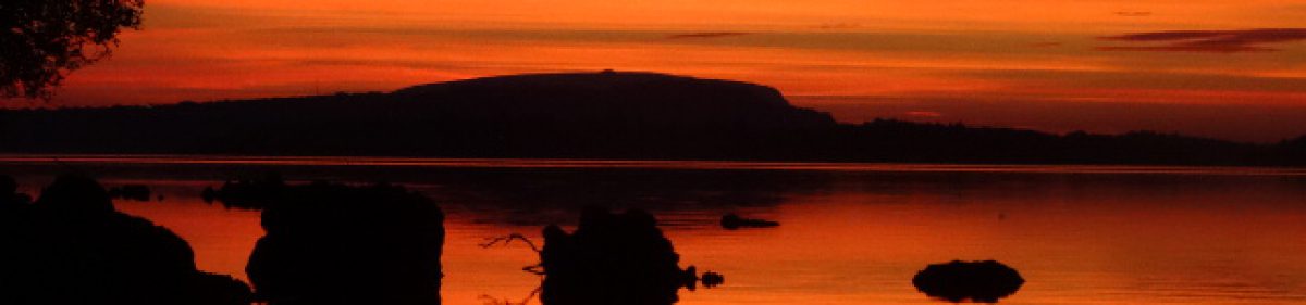
Weather forecast said it would be mild, blue sky from 3-4pm so I planned to be reaching the 1st objective around this time, which was actually the 1st summit, named Ben Bury/Oughty Craggy. Purely for the light as this is often what will make or break a fine adventure, and a photograph, and there’d be plenty of time before dusk for me to finish route, and get back to van, and if it got dark, I had a torch. Sounded like a good plan to me, however I kind of messed this up. Thought I’d loads of diesel to get me there and back to garage just outside of Castlebar to refuel and get me home.
I do this always when I’m in the area as I’ve usually got a good idea in advance of when I’ll be there. He’s got the best prices I know of for maybe 70/80 mile, maybe in the whole country. It might not sound like much, but compared to other garages he’ll be 5/6c per litre cheaper than most competition, but even if it’s 2/3c cheaper, each time you fill ya tank from empty you multiply this saving by 40/50. It all adds up believe me.
I was on fumes when parking and didn’t know where nearest garage was, But 1 thing for sure, this tank wasn’t getting me back to Castlebar, I didn’t care put it to the back of my mind and thought well if I have to walk to a station later that’s fine, now let’s climb, deal with that other thing later. But now I know I want to get back to Castlebar by 8, not sure what time they close at, this should be safe.
So now I’m watching the clock, can’t really relax and take time with photos and waiting for wildlife, but when do things like this go perfect?? Now for the climb. Parked at grid ref L 822:702 beside the monument and started in at 1pm after txt to Barry. For those of you new to grid references or unsure about them, here’s a link to follow which will explain it all. Grid refrences
This MI website is a very good resource and there to use by all, with a wealth of info and interesting tips and tricks. Worth having a look as you see fit.
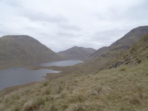
So decided to head up around the north end of Lough Glencuillin for the first time too as I’ve always crossed via the land bridge between the two lakes when on approach or return. No problems here and the brisk walk up the farm track worked as a warm up before getting into the climbing, which was nice and easy to begin.
There’s a gully flowing which you can clearly see from the road and I just love these features and time to play on my hands. You’ll find interesting plant and wildlife here on any given day if you’re patient enough and look, and they’re always scenic and offer another type of challenge, to climb or descend them as water will always take the shortest route down and carve out its own route. A bit like some people. I’ll re-visit this gully another day, soon maybe. Today I go up and around it and cross the river as it starts its way over the crest of the hill.
Whistles, and in the distance a farmer herding his sheep with a hard working dog at his side, so as the sheep approach, I still myself in order not to spook them and let them pass as they seem to know where they should be going, and I can see the farmer maybe 250m distant and uphill from me, which is the general direction I want to be going, so decide to go and say hello to him as it’s nice to be nice, though then he was gone. Obviously working hard. He probably saw me as I’m all bright colours today, so I get back on route toward the spur I was headed for.
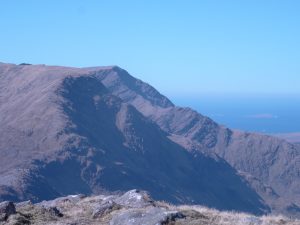
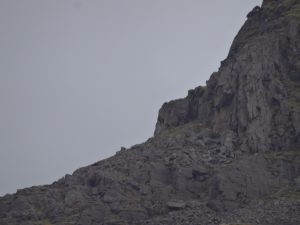
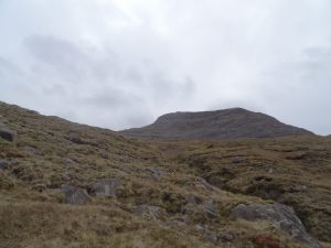
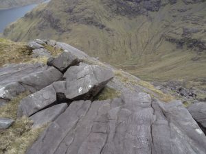
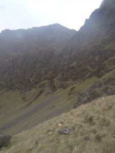
On the spur and with the zoom lens on the camera I snap of some pics of the route ahead and see where it got the name Oughty Craggy. Craggy being the operative part of this, with its intimidating cliff faces, boulders, rocks and scree fields. From this distance it looked impenetrable almost, but often when you get your nose to the rock you’ll find routes, paths hand and foot hold, but one thing for certain, it was going to be equally interesting and challenging.
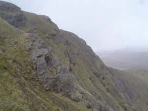
There’s a few false summits, shelf-like on this spur, then the steepest part was going to be the final one, this I knew from research but was still thrilled when it materialized in front of me. Still some way off and picking a route through this looked daunting. It was also somewhere at the bottom of this area yer man was found last year, there were friends of mine in the search and rescue operation for days, so I’d have to be careful. And there, a route, or at least to somewhere higher and around the corner and then decide from there, continue or backtrack. This looks doable, let’s do it.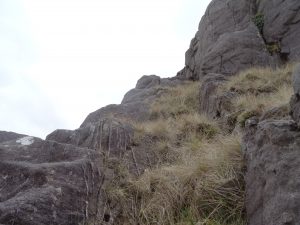
The scramble begins so camera and walking pole away as I’ll need two hands and if I stumble I don’t wanna smash camera off a rock. Hands and feet, always maintaining at least three points of contact where necessary and it’s full on focus. This stepping stone/sod of muck/piece of grass/hand hold, will it hold or slip. If it slips do I go plummeting or will my other points of contact hold me, anon. Now and then a safe harbor and take a breather, sup of water, photo or two then continue. At this for 20 minutes, then a whistle, rumble and barking, sheep approaching toward me like mountain goats, don’t spook them or they could fall, and there the dog and more than one dog by the sound of it, I round a
boulder and there above me I just make out the farmer maybe 30m away and above me, just his head between rocks, then they were gone again. Would’ve made a good pic but camera was anchored.
I continue climbing and making decisions, always making sure not to climb myself into a trap, or in other words, assess if what you’re climbing can safely be down climbed and if it can’t, don’t do it. Heart thumping, excitement, and in my head the mantra, “do nothing in haste, do nothing in haste, do nothing in haste”, shortened from the famous Edward Whymper quote,
But I wanna finish the planned route and be back in Castlebar before 8 for the nice price diesel, “DO NOTHING IN HASTE”!!! I can change and shorten the route later if necessary. Don’t need to get to Mweelrea today. Then there’s the other well-known ditty of getting to the top is optional, getting back down again is mandatory, so slowly onward and upward, decision after decision, this rock here, climb over or skirt under it, and there it is. Nearly jumping for joy as in front of me, just across a narrow boulder field the final ramp and escape route to the summit of Ben Bury and were up. Nice one. Took a few pics and straight on toward Mweelrea.
And I’m down, on me arse soaked in a mud puddle after landing hard on my left arm, possibly twisted, sprained, ligament damage? And camera in mud puddle too. Feet just slipped straight out from under me in the lovely Irish bog. As soon as you relax and assume the risks are behind you
for time being, it’ll bite you. But I’m alright, arm and shoulder bit sore and camera is just stuff, it’s replaceable, equally cursing and laughing. I’ve always been known to say that if you don’t get back to civilization caked in mud, how’re the people there to know you had fun otherwise. So Summit at 4pm, txt Barry, ah good stuff sez he, was starting to wonder, flask of tea, bikies, and rest for a while.
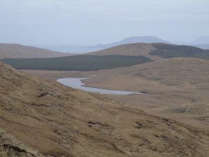
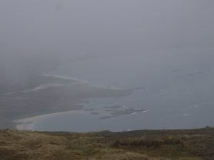
Marvelling in the stillness of the scene and the solitude, surrounded by the elements and forces of nature, being just brushed by the lower levels of the cloud. Can just make out some of the Islands below and somewhere, not too far away the ever present ravens calling back and forth, talking to each other, acrobats of the sky dancing their sky dance. Peace.
4:20, gotta go, getting chilly and on the clock so head back the way I came, it’s mostly all downhill from here, then veering to top of ramp which is in a col and marked by two cairns, one smaller than the other. This section is a little tricky and must be taken seriously for a fall here could also be very bad, but it’s just a short section leading to the well stomped path below, which still warrants your full attention. It’s equally 1 part rock and scree,
1 part dry solid ground, 1 part slick mud and moss, interspersed with a few streams flowing this way and that. So slowly, easy as she goes, remember the mantra? There’d been a lot of rain in the area in recent weeks so this didn’t help with the slick parts and after a dry spell it wouldn’t be as bad obviously, so it always pays to try and get and recent weather report for which ever area you’re going to. These can be got online from many sites.
Honestly today I slipped and lost footing maybe 12/15 times during this decent of the ramp to Doo Lough and it’s just quick reflexes that stopped me from hitting the deck every time but once.
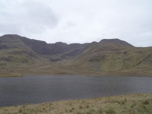
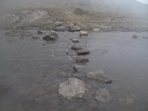
It’s also around this time of day a person starts to get tired and if not careful and aware of this, to make mistakes, so you can’t forget to stop from time to time to enjoy it, rest if you have to and refuel and then continue. To the banks of Doo Lough and across the land bridge which is intersected by a river with some nice conveniently placed stepping stones, but if you don’t fancy these or have shorter legs there’s a sturdy looking wooden bridge just a few meters upstream and once across make a beeline toward the van.
I get chatting to a guy who’s parked beside me and he’s operating a drone, making a film on the Irish famine which I’d like to see whenever it’s done and he knows the area better than I, so when I mention my fuel predicament he suggests Louisburgh’s your best bet for direction you’re headed and the map confirms this. Another 1st for me
as I don’t believe I’ve ever been to Louisburgh, possibly passed through it, but head that way and if you get stuck on side of road, I’ll be along in a few mins once I wrap up this filming here.
So 6:45 and headed off after safe down txt, €5 in the van to get me to Castlebar for 7:45 to fill up tank, which is still half full a week later. I love it when a plan comes together.
Statistics,
Distance,

13K.
Ascent/descent, 1159m
Duration, just under 6 hours.