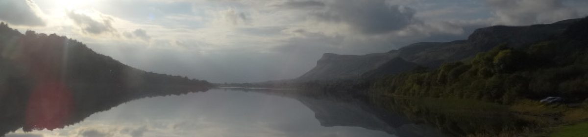

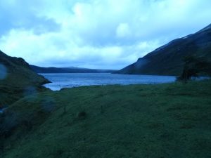
 Donegal, magical, mystical, spectacular and voted by National Geographic no less, as the number one destination on the planet for adventure holidays recently. This is the home of the mighty Glover Challenge, a very popular route on the Irish challenge walks calendar, with which I had unfinished business. After attempting this route two years ago in horrendous weather conditions and opting to pull out due to concern for myself and those around me who might choose to follow had we continued.
So when it came up this year to do it with SMC, you’d have needed wild horses to keep me from it and 11 of us headed north to give it a go. The rest of the group got there on Fri to stay in the Eirrigal Youth Hostel, a fine building but due to financial constraints this was no option for me, so I decided to bring a tent, sleep over and meet the guys in the morning for bus to take us to the start of the hike. This is a linear hike by the way.
But the closer it got to the kick off the worse the weather forecast got and I was faced with the likelihood of pitching and striking camp in the teeming rain and being soaked to the bone probably, and tired 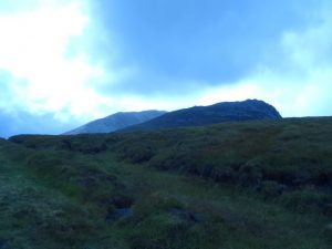 probably, meeting the team at 6:15 am to head on our adventure? This didn’t seem to make a lot of sense to me so plan b came into effect. It’s just a 2hr30min drive from my house to meeting point, hostel, so leaving at 3:30 should give me lots of time and traffic would be light.
It worked well and I opted to take the coast road there, up through Glenties and it was a while since I took this route. I drove it regularly a while back as a lorry driver and it was bad then. It’s improved immensely and I must say it’s a real drivers dream. I thoroughly enjoyed the drive and it’s more scenic than going inland through Letterkenny, though this is nice in places too. En-route, just leaving Coolaney I see a car just pulls out in front of me, flashing lights in my direction so to see what’s going on, I slow and lower window, “what’s the crack, you all right?” sez I.
Where can I buy smokes an food sez yer man, in a foreign accent so I do some quick calculating, this guy needs a smoke, Sligo town and I’m heading pass there, follow me. Good plan sez he, he does a u’ey and pulls in behind for the hungry rock, turn right to Ballisodare, I checking rear view to make sure he keeping up, motorway to the flyover. Pull in and he come along side.
Up the exit ramp, 2nd exit, about 1k on yer right’s the 24hr, smokes and grub. I’m going straight, good luck to ya. “Thanks’ and may all the gods smile down upon you, my name is Michael Martin Stephen John Thomas O Donnelly O Muruchu O Reilly” sez he as he making the sign o the cross in my general direction, sending me blessings. He don’t look like a priest and this chap’s WIDE AWAKE, so I sez I’m Niall, good luck 2 ya, box clever. All the best. On his way he goes and me on mine, at 3:30 am. Interesting encounter. He may have been a DJ or something on the way home.
So the rest of drive was pretty uneventful as drives in the dark can be. Just keeping her between th ditches in th rain, on roads already full of standing water in places and I knew sun’d be coming up as I drove north. Then just before I crossed the bridge at Lettermaccaward, just after Mass, on the nice newly resurfaced road, about 20m in front of the van, as the darkness is ebbing I see the biggest, reddest bunny I’ve ever seen in my life so far. In no hurry as he hopped across, on a mission only known to itself and possibly just 1 or 2 others. This creature is the colour of the red rebel’s noggin I kid you not. And there’s gotta be more than 1.
I arrive eager and rearing to go as the guys are just making last min preparations. I’d a tent with me so I might camp here after the hike, save me the drive back and weather’s set to improve in the afternoon and following few days look better. Can explore a bit. We’ll see.
Bus arrives and we all pile on and he’s a local so knows the backroads and which ones the bus can go down’ so 45 min (I think) later we’re there at the north side of Muckish, disembarking at the old quarry, and thick, heavy, wet cloud all round so some of us on the waterproofs, but it’s warm. Try move slow and steady so you don’t sweat too much with the extra layer. Easier said than done this. The north of Muckish looks formidable, and very steep. In places it can be lethal if you make a mistake but there is a route up it.
This side use to be a quarry for building materials I believe, so there’s stone steps here and there in different places, leading up to the remnants of an old cable car system, about halfway up, and then you can find a route which continues higher and to the summit.
I mentioned earlier the Challenge Walks Ireland calendar, and there’s an organised event held here 1ce every 5 year so keep an eye out for the yellow arrows pointing the way ahead, take your time and you’ll find them every 50 – 150m, as long as you’re not just looking at your shoes that is, follow these arrows and they’ll lead you to the top. Straying too far from this route could be very bad as there’s shear drops, cliffs and boulders everywhere. Not sure who’s in front of this posse or who’s navigating but I was up here two yr back and they don’t seem to be going too far of course.
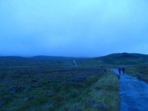
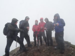
Some of em done this route before also, they’re using viewranger mapping breadcrumb software, so I can chill out and shoot th breeze. Quick group snap at Muckish top. I’d gone over this route on map prior to leaving home and knew south east-ish, and this is the general direction we took. Also you’d hardly need a compass or grid ref measurements if you just have good vision and can see the path ahead, the one thousands of other feet landed on their way along the Glover challenge. Trail’s there.
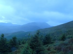
We drop down to road and the layby where there’s a regular refuelling point so I wait as the guys all refuel and get ready for next section. To tell truth I’d have kept going but was with the group so in these cases I’m easy going enough. Up and up, and up a bit more, nice and gradual to an obvious spot-height, no-where near the forestry boundary and bearing in mind, there’s 3 spot heights, the 3rd one’s our objective, “461” and from here in the mist our north east our next stop is Crocknalaragah. Off we set in that direction where there’s a typical checkpoint on the organized events. None this day but we find no prob.
Here we’ve a wee discussion as to best way to continue. We’re not all in agreement so decide to split up. Me and Colm/Vs rest of em following their breadcrumbs on viewranger. Probably a predetermined course they’d plotted long before leaving, sez we’d all hook up at Lough Alurig, just where river leaves the lake. Sound, done, good luck. Me’n Colm, we panicked some plover and hopped a fence or two. Good technique btw for hopping fences. And found our objective no prob. Way ahead of the others so this was nice.
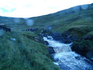
Chill outa th breeze and have a cuppa. Settling in and other party eventually arrive. They take a leaf and all’s good. We discuss the weather and probably the whistle calls, or maybe tha was earlier. All this sittin round drinking tae in the damp will chill ya if let, so we split. Colm heads 1st as he tends to do, then me and the rest follow. Up and up toward Aghla beag. I find myself solo here for a while and find it quite nice. Hear some voices off to my right so a whistle and we regroup, headcount, are we going to Ardloughnabrackbaddy discussion and some1 decides, nah we don’t need to go there. Think I remember who opted out but woulda been nice I thought. Well,,, next time.
Twas around here I’d noticed one of our number was moving a lot slower than normal. I’d spoken to him already about carrying your house on ya back on a trip like this. Didn’t weigh his bag but it looked heavy and sez he’s in training for upcoming event. He a fit lad. Hill-monster but one having difficulty now due to old injury play up unexpectedly, but cest la vie eh?. Jimmy’s already donated his walking pole for the cause. Ya seldom see Jimmy on the mountains without one so now I’m watching both Jimmy in case he’d falter without his pole, and the guy who’s doing his best to keep up.
Jimmy, ya really should get a basket for ya pole BTW, you’ll find it makes life lots easier. So on and up and down and up a bit and down a bit, all in the mist, Eaghla More’s long behind us and our pal with the injured wing’s in a bad way so me’n Jo, the doctors’ wife stop to see can we help. Doctor’s not far and Jo gives some pain killers. I sez if you can make it downhill for another bit, I’ll take a look there, can you make it tha far. I knew it was a good sheltered spot and the rest of group had this in mind for another refuelling area, Altan Farm. Yup sez he, think so. On we descend. Following our viewranger breadcrumbs, not my idea btw and it actually slowed us down. We could see the way ahead at this stage, from what’s on the map, (osi I use), and what was visible on the ground as we’d just dropped outta the cloud at this stage, but that’s the truth.
This viewranger plot and follow a route seems a bit like a Pacman game if ya ask me, and the group must wait while Pacman finds his way. WTF if the battery goes is all I wanna know.
Regardless we get down the hill and find a cosy enough spot outa the worse of the weather conditions. Getting set for a nice cuppa and slice o banana bread. Others are taking pics or feeding their faces and playing touch my toes, wonder can I, and our injured pal gets in. So as promised out comes my 1st aid kit with the creams and stuff. He asks how to use and a guy sez, “ya don’t need to take trousers down, you can apply bandage over trousers”. I’m asked and advise, “Don’t put cream over ya trousers”! Think about it, pity ye weren’t there if ye weren’t there.
In hindsight I think I shoulda wrapped it tighter, but was trying to be ready in case there were more injuries later, and I’d forgotten 1 of Micks’ golden rules. I can still hear him now, “I wouldn’t give em a sock”. Long story to explain but basically I should’ve asked for yer mans’ 1st aid kit and used this for supplies if possible, before raiding my own. Or I could’ve asked other team mates if they’d a roll or two with them, just in case of emergencies. Next time, and he did say the Etoflame worked and he’d felt better after the wrap. But my adventure for this day was far from over, and there was potential for further injuries. Back to the cuppa and snack, check map and route ahead.
Having it!!
So from Altan farm to Eirrigal it’s not that complicated. Nearly linear, or as the crow flies on a map. Two spot heights, one a bit higgledy piggledy looking on our route, but if you can imagine a straight line, of such a distance and using map memory. You’ve Beaghy, Mackoght and Eirrigal. Simple. Spot height to spot height, spur to saddle and again. You’ll be climbing on a spur, where the track is. Sound, memorised so I can put map away to free up a hand I may need, and so it and map case is outa my jacket where it’d been quite a lot of the day, when it wasn’t being used, adding to non-needed insulation and overheating. It had been out for quite a lot of the day as it was being used.
Beaghy was interesting in the mist, Mackoght was very rocky with boulders to scramble over strewn about everywhere but no major problem and we get down toward the saddle. Our lame comrade has decided on prudence and vowed to head back to car from here. Last chance and this was the closest we’d been to car all day. Mathias volunteered to walk out with him. Another of our party has a great brainwave. Why don’t we all walk out from here and 4get Eirrigal all together, as we’d all been up this before, weather’s a bit overcast, and my legs are tired. Well stuff tha missus I’m thinking, but say,
“I sacrificed and came here today to climb this and that’s what I intend to do, ye can do what ye like”
So straight away Colm and Jim were in and we didn’t have to ponder that ridiculous idea any longer. Eirrigal is after all what can best be described as the jewel in the crown of what the Glover challenge is all about.
Another big long steep climb at the end of a day that’s already been full of such. Forego it indeed.
Ended up 9 of us climbed it. I’d a trick up my sleeve which I’d kept to this point. A secret weapon I’d not used before but had heard about from friends, and that secret weapon is dextrose. Basically pure glucose in a sweet form to be used as needed for a quick pick-me-up or a boost. Energy wise and focus wise. So I offered em round to all and there was a few takers. Some were happy enough with sambos. Somehow we all found the shoulder, and each other again after becoming temporarily separated, as we scrambled over boulders, some of which were quite mobile and teetering if stepped on wrongly. I’d pointed at the spur to our left, I could just make out the outline, a darker grey among the other grey, where our track lay, compass in hand. . Or maybe they didn’t hear me proper. Next time they’ll hear me in Clondalkin and I’ll make damn sure of that.
And basically I was criticized and shot down for not having my map in my hand, by yer man following his Viewranger breadcrumbs, followers in tow as they headed further from our route. So far in fact we’d to ring him to find out wtf he was going
But all’s well and once on the spur you can’t really get lost. 10s of thousands of boots have worn a track over the years, keep climbing and when there’s nothing left to climb you’re at the top. The dextrose was kicking in, or maybe adrenalin, or something else but once I got by some of the others who’d managed somehow to get in front of me then go to sleep in my road. Once I got past these I near ran up Eirrigal, except I don’t really believe in running for fun. But there was no stopping me. Leaving the guys behind, which I don’t normally do, as a matter of duty (sometimes self-imposed) so I stopped to look over shoulder a few times to see they were still coming, then on again just as quick, if not quicker. From looking at pics and research I knew Eirrigal consists of two peaks, and it’s a narrow ridge linking the two. I’d get a pic of the guys up hear who’d done this far. It’d be the only snap I took that day, but the rain had eased enough to allow one quick pic before putting it back in dry bags.
Now where’s the camera, not in its usual place. Look again, other pocket no other pocket no, SH1T, think, must be back at Altan farm where we’d tea, then remembered that while I was helping with the 1st aid earlier I’d a lot of dry bags around and taken out. Stuff I wouldn’t normally need to go near on a hike so maybe camera ended up in there by mistake and Yess!!!! Happy out, disco. Camera in paw I join the guys on 2nd summit and get the snap.
Colm snapping away too, good on him and well done and congrats all round. We’d still to get down. The last of the two to summit that day had arrived only after I’d put camera away and some of the others had left, but I’m glad I waited on them and not raced the others down. Just to see the smiles on their faces as Colm took their pics was worth all we’d been through, they were that happy. We’d still to get down though and this is anything but a given when you mix the terrain, weather conditions and tired bodies to boot.
So remembering my training and responsibilities, the lessons, do nothing in haste. A group’s only as quick as its slowest mover. Besides what’s the point in getting back to ya car half hour earlier if ya gonna be waiting for passengers or drivers anyhow? Always stay in touch with guy in front and behind and match speed accordingly. Whistle calls are effective too, shouldn’t be needed if each are towing the line, but we a good team and we all get down. I’m sauntering along at the back with a couple of great companions, the doctor and his wife, out enjoying a schlep through some slop, enjoying the last of our hike, we’ve lost the well-worn track amidst the long grass and heather, pools and puddles but we hear the road ahead and know to head downhill.
Back to the van, quick splash and dash while the guys are getting all set for a night out, I just want food and might camp, might go home. Weather not lifting, home it is. Great steak in posh hotel with mediocre service if you ask me. I can elaborate but won’t, I eat, say good byes and run back in van at 9:30, picking up dog at 11:50, and he’s just delighted by this and I’m home at 12. A long day well spent. I slept well that night.
The one snap I took on the day is included with those added and the rest are from two yr back when we let the weather have its way. It was a foul day too and camera was again sheltering most of the day. Will possibly be back. There’s other challenges out there. Let’s do em. ;-}
is that the place you have visit?
It is surely, How else d’ya think I got the snaps and came up with the speil Muhammad? Maybe you’d like to join us the next time we’re planning to do it. Could be some day soon now.
This blog was… how do you say it? Relevant!! Finally I’ve found something which helped me. Appreciate it!
Hiya Rebeca, please tell me more, not quite sure what you mean or how you find this relevant? Is this a hike you’ve done yourself b4fore, or are planning to do? Or you’ve done similar, please tell me more. Sure, twas a gr8 hike in gr8 company, would love to go back and do it again, but hopefully better visibility, as we’d nothing but pea soup all that day.